Wood structure and water level
Wooden piles and planks rise and fall with the water; in the dry season the piles are exposed, in the rainy season submerged — a unique over-water causeway image.
🔗 Rating & review count synced from Google Maps · verified September 2026
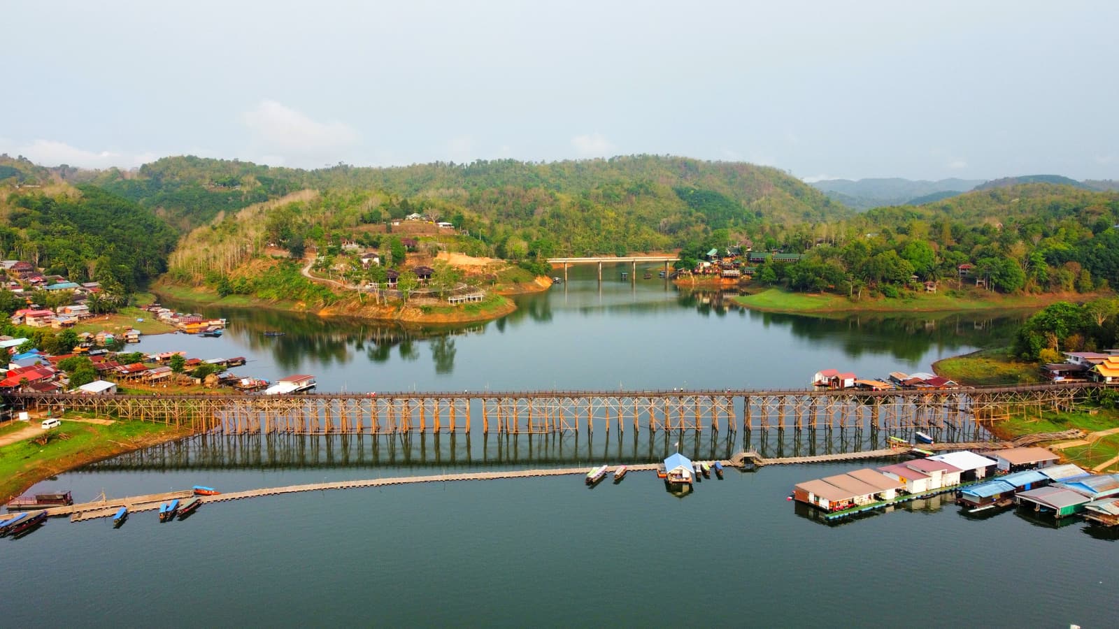
A wooden bridge spanning the reservoir in Sangkhla Buri, Kanchanaburi, built by the local Mon community in 1986. It is the longest wooden bridge in Thailand and a symbol of Mon culture and border-town life. The bridge shifts with the water level and is at its most photogenic in morning mist and at dusk. Open 24 hours a day, free of charge — a perfect spot for reservoir sunrises, the Mon village, and borderland culture.
🔗 Hours & transport per Kanchanaburi official info
Mon Bridge is more than a wooden path across a river — it is a bridge the Mon villagers built with their own hands to connect two communities. Every step on the planks is a quiet tribute to this borderland and to Mon memory.
— The Mon community of Sangkhla Buri
Golden Hour Calculator · Light Tool
Based on today's sunset, we recommend arriving about 60 minutes earlier to catch the softest diffuse light and the blue hour on the water — ideal for photographing the bridge causeway, the Mon village, and the hills across the reservoir.
The bridge faces the open reservoir, with the warmest light from dawn to dusk. On weekends or clear days, allow extra time to avoid crowds.
🌊 Sunrise tip: the bridge spans the reservoir and is a popular spot for water sunrise. The moment the first light touches the bridge and the far hills is the golden window for photography; misty mornings in the rainy season call for warmth and moisture protection.
⚠️ Water-level safety: the bridge spans a reservoir; when the water rises in the rainy season and waves grow, the planks get slippery and some sections may be restricted. Check Thai water-resource and local notices and follow on-site guidance. Water level info ↗
Light changes through the day — for reference only
Arrive by
—
Blue hour
—
A few numbers to read this borderland bridge at a glance.
Bridge / Bridge
Thailand's longest wooden bridge
Spanning the Songkalia River (Khao Laem Reservoir), built of wooden piles and planks, it is the longest wooden pedestrian bridge in Thailand and a landmark of Sangkhla Buri.
Built / Built
First built 1986
Built by local Mon villagers in 1986, connecting the Mon village with the town across the water — a lifeline for daily community travel.
Reservoir / Reservoir
Songkalia River
Below the bridge lies Khao Laem Reservoir (Vajiralongkorn Dam). Water recedes in dry season and rises in rainy season, giving the bridge a different look each season.
Culture / Culture
Mon community
The Mon village at the bridgehead preserves language, dress, and Buddhist tradition — a key window into Mon culture in Thailand.
Coordinates / Coords
15.1434° N, 98.4498° E
WGS84: 15.1434, 98.4498. Plus Code: 4CVX+9W Nong Lu, Sangkhla Buri. Address: 1 Saphan Mai Alley, Nong Lu, Sangkhla Buri District, Kanchanaburi 71240, Thailand. Rating source: Google Maps (4.6 / 12,009) · verified Sep 2026.
Admission / Admission
Free
Open 24 hours, free of charge, maintained by the local community — easy to visit lightly at any time.
Travel weather
Check before you go: temperature, rain chance, UV and sunset time — enough to decide whether to pack an umbrella and when to arrive for the best light.
Fetching the latest weather…
The forecast refreshes continuously; mountain microclimates shift quickly, so always confirm on the day you travel.
Mon Bridge (Thai: สะพานมอญ, official name Uttamanusorn Bridge) lies in Sangkhla Buri, Kanchanaburi Province, Thailand, spanning the Songkalia River (Khao Laem Reservoir). It is the longest wooden bridge in Thailand. Built by local Mon villagers in 1986, it connects the Mon village with the town across the water — a community lifeline and an important symbol of Mon culture in Thailand. Maintained by the community, it is a borderland landmark for villagers' passage, travelers' strolls, and photographers' pilgrimages, and one of Sangkhla Buri's city cards of 'bridge, water, Mon'.
Mon Bridge lies in Sangkhla Buri, Kanchanaburi Province, spanning Khao Laem Reservoir. Built by local Mon villagers in 1986, it is the longest wooden bridge in Thailand. After storm damage in 2013 it was rebuilt by the community and reopened to the public — a borderland landmark for villagers' passage, travelers' strolls, and photographers' pilgrimages, and one of Sangkhla Buri's city cards of 'bridge, water, Mon'.
Welcome to Mon Bridge (Uttamanusorn Bridge), widely recognized as the central Mon Bridge. Located in the heart of Sangkhla Buri, Kanchanaburi, Thailand, this destination serves as a primary hub for travelers visiting the region.
Mon Bridge stands at 1 Saphan Mai Alley, Nong Lu, Sangkhla Buri, Kanchanaburi (Plus Code 4CVX+9W; 15.1434° N, 98.4498° E). It is a few minutes from Sangkhla Buri town centre on foot or by car, open to the public all day and free to cross, and reachable by road via Highway 323.
When visiting Mon Bridge, visitors can easily explore surrounding historical landmarks and points of interest, including Wat Wang Wiwekaram and Three Pagodas Pass.
Built by local Mon villagers in 1986, Mon Bridge spans the Songkalia River (Khao Laem Reservoir) as the longest wooden bridge in Thailand and a community lifeline linking the Mon village to the town. Rebuilt by the community after storm damage in 2013, it now serves both as villagers’ daily passage and as Sangkhla Buri’s signature “bridge, water, Mon” cultural landmark.
For official updates and regional tourism information, visit Thailand / Kanchanaburi Official Tourism Portal .
Putting the Mon villagers' building, the 2013 damage and rebuilding, the reservoir's natural formation, and Mon culture on one timeline is how you truly understand why this bridge is more than 'pretty wood'.
Mon Bridge was built by local Mon villagers in 1986. The Mon are one of the ancient peoples of mainland Southeast Asia; some groups migrated from Myanmar to the Thai border and settled in Sangkhla Buri. Built of wooden piles and planks, the bridge connects the Mon village with the town across the water — a community lifeline and a humble wish to 'be connected by a bridge'.
In Thai the bridge is called สะพานมอญ (Saphan Mon, 'Mon's bridge'), with the official name Uttamanusorn Bridge. Sangkhla Buri has long been a border town where Thai, Burmese, and Mon peoples meet; the bridge meshes toponym, water color, and Mon memory on the same reservoir, and is also the traveler's first greeting on arrival.
The bridge spans the Songkalia River, today part of Khao Laem Reservoir (Vajiralongkorn Dam). Water recedes in the dry season and rises in the rainy season, giving the bridge a different look each season — making Mon Bridge both a community path and an open-air reservoir classroom.
The Mon village at the bridgehead preserves the Mon language, traditional dress, and Buddhist faith — a key window into Mon culture in Thailand. Villagers speak Mon daily and wear traditional dress at festivals, continuing a cultural memory tied to their homeland in Myanmar.
Sangkhla Buri continues a deep Buddhist tradition. Each year at the end of Buddhist Lent (Ok Phansa, roughly Oct–Nov), the famous 'Tak Bat Devo' (เทโวโรหณะ, descending alms-giving) ceremony is held: monks walk in procession across the bridge to receive alms from the faithful — the bridge's most representative religious and cultural spectacle.
By the bridge, Wat Wang Wiwekaram was built under the Mon senior monk Luang Pho Uttama and houses a stupa modeled on Bodh Gaya in India. In the dry season, when the reservoir recedes, the submerged old temple (the 'sunken temple') emerges — a unique landscape and memory.
Sangkhla Buri is a border town where Thai, Burmese, Mon, and Karen peoples live together. The bridge connects not only two shores but also different languages, faiths, and ways of life sharing the same reservoir bank.
The bridge faces Khao Laem Reservoir, a ecological belt where mountains meet water. Waterbirds wheel and the water level rises and falls — a natural classroom for observing western Thailand's border landforms and migratory birds. From community path to reservoir ecology, the bridge shows a typical example of human-water coexistence.
Wooden piles and planks rise and fall with the water; in the dry season the piles are exposed, in the rainy season submerged — a unique over-water causeway image.
The reservoir is key habitat for waterbirds and fish, most active at dawn and dusk, echoing the Mon spirit of 'respecting water, cherishing life'.
Morning or evening is when water color and bird shadows are most vivid. Stand quietly on the bridge to observe the water level and birds feeding.
First take in the whole reservoir outline from a high point at the bridgehead, then go onto the bridge to observe the water level and village up close. Distance shows overall form; close view reveals the bridge-water bond.
This section is a science overview based on Sangkhla Buri's public interpretation and on-site features. For stricter geographic and ecological classification, rely on official materials, on-site signs, and academic research.
About the bridge and reservoir, a local oral tradition tied to 'the protection of the water god' is passed down: it is said the bridge's building was blessed by the water, and in years of abundance people came to give thanks. Such legends may not appear in official histories, but they let the public sense how this land was imagined and cherished.
Mon Bridge is more than an over-water causeway — it is an open-air classroom of community memory and borderland culture: from the Mon villagers' building, the 2013 damage and rebuilding, to Wat Wang Wiwekaram, the sunken temple, and the 'descending alms-giving' ceremony, the story of land and faith is written on the same reservoir.
When you visit the bridge, what's worth reading slowly is often not the check-in board but the official signs explaining 'why this bridge is here'.
The readings below are based on the bridge-history, Mon-culture, and sunken-temple signs set up by Kanchanaburi Province and the local community, translating information visible on-site but not always read into accessible English science notes.
Mon Bridge (Thai)
📍 On-site location · Bridgehead main entrance
These signs state the key background — the meaning of Mon Bridge as a community path and its building relationship with the Mon villagers. Reading the hints is lesson one in using this over-water landmark.
Mon village (Thai)
📍 On-site location · Village entrance
The guide repeatedly emphasizes the Mon village as a cultural window and reminds visitors that this bridge is half practical passage, half the community's Mon imagination. It clearly explains 'why it is the Mon's bridge'.
Khao Laem Reservoir (Thai)
📍 On-site location · Bridge viewing area
The map explains 'why this is a water vantage'. The reservoir's rising and falling water shapes the bridge's seasonal look; seen with the Mon village, the bridge's design logic becomes clear — passage and water coexist.
Wat Wang Wiwekaram (Thai)
📍 On-site location · Temple plaza
Erected by the local community, it marks the cultural relationship among the bridge, the village, and Wat Wang Wiwekaram, echoing the 'respect water, cherish life' motif. It reminds every visitor: this wooden bridge connects the quietest borderland memory.
Look past the surface 'pretty' to find what's truly rare about this bridge: it is at once a borderland community path, a Mon memory, and an open-air classroom of woodcraft and hydrology.
The community story hidden in the bridge
Mon Bridge's hardest core is both visible and invisible. Visible are the wooden causeway and water views; invisible is the Mon memory and villagers' passage wish it carries. Visitors see the landscape; villagers see how this bridge links two communities on the same reservoir.
Mon Bridge's cultural symbol
The long causeway, reservoir hills, and Mon village, together with the water, form Mon Bridge's identity system: reading instantly as Sangkhla Buri, as borderland, and as a gentle, transparent over-water aesthetic. From bridge-deck water views to village cooking smoke, this contrast makes it one of the borderland's most memorable images.
What's most worth learning about the bridge isn't 'it got prettier' but how it re-integrated a reservoir waterway into the public's Mon memory while keeping reverence for nature and community.
The bridge isn't a 'hide the water and done' case, but a model that activates passage memory through community maintenance and turns it into a shared place.
Signs, bridge, and guide systems aren't just navigation but let every visitor, while using the space, casually respect the community and others.
The bridge didn't erase the Mon background but, through village, temple, and signage, lets the public sense what this land has been through while visiting.
Look past the 'pretty bridge' to find what's truly rare about the bridge: it turns a reservoir waterway into an open-air classroom that changes with the seasons.
Cool-season water
The cool season (roughly Nov–Feb) is when the bridge first wakes. Comfortable temperatures and easy morning mist, with clear water color, form the borderland's brightest over-water palette.
Rainy-season water
The rainy season (roughly May–Oct) brings high water; the bridge feels more immersed — a good time to observe hydrology and migratory birds.
One reservoir, four tempers. Below, the scenes most worth expecting each season.
COOL
The dry, comfortable season before temperatures rise; morning mist and clear water, best for slow walks and dawn shots.
HOT
The hot season (roughly Mar–Apr) has bright water but strong midday sun — best at dawn and dusk.
RAIN
The rainy season brings high water; the bridge floats on the surface — the most vivid time to observe hydrology and birds.
YEAR-END
Around the end of Buddhist Lent (roughly Oct–Nov), ceremonies like Tak Bat Devo make the bridge the most culturally charged season.
Not just 'you'll like it,' but directly telling you how to walk, where to go first, and which Kanchanaburi nodes to link.
Resonance: Free, open, flat bridge — kids can watch the reservoir and hear the Mon story, and easily reach mid-bridge along the flat side.
Tip: Spend energy on photo stops, not on crowding; mind the waterside wind.
Resonance: Dawn reservoir sunrise and bridge backlight are Sangkhla Buri's most romantic frames, with very high hit rate.
Tip: Count arrival, return, and light into the plan so composition isn't beaten by on-site pace.
Resonance: As a culture-and-nature sample, Mon language, wooden craft, reservoir ecology, and birdwatching are worth a close look.
Tip: Avoid the most crowded weekends; choose dawn or a weekday afternoon to really observe details.
Resonance: Without going far, experience western Thailand's borderland multi-ethnic and Buddhist culture; link buses, taxis, and local food — an ideal start to the 'bridge, water, Mon' theme.
Tip: If you can pick only one Kanchanaburi borderland landmark, the bridge opens the 'water and bridge' theme best.
Season by season
Weather, water level and quality, and wildlife activity combined in one table to help you choose when to visit and how to spend the day.
📊 Compiled from the 1991–2020 climate normal period (Thai Meteorological Department climate normals) and public hydrological observations from the Thai Department of Water Resources, together with local reservoir operation patterns.
| Season | Weather | Water level & quality | Wildlife | Visit advice |
|---|---|---|---|---|
| Nov–Jan Cool season (best) | Daily 22–30°C, lower humidity, misty mornings, least rain and best visibility. | Medium-low level, clear water with little algae and the strongest reflections. | Winter migrants arrive; waterbirds and egrets are active, with mist and birdsong at dawn. | The most comfortable window of the year. Shoot the misty bridge at 06:00–07:30 and bring a light jacket and non-slip shoes. |
| Feb–Apr Hot season | Up to 35–38°C by day, extreme UV, isolated rain with occasional short-lived storms. | Lowest level of the year; slower flow in places, more algae and comparatively turbid water. | Insects and butterflies thrive, fish gather in deeper water, and animals are active at dawn and dusk. | Avoid 11:00–15:00 sun exposure, visit early or late, and take hydration, sunscreen and heat exhaustion seriously. |
| May–Jul Early rainy season | Frequent but mostly afternoon showers, 25–33°C, clear air and lush green vegetation. | Level rises quickly and sediment load increases after heavy rain, briefly reducing water clarity. | Amphibians and insects are abundant, many plants flower, and birdlife increases along the reservoir. | Visit in the morning, carry an umbrella and a dry bag, and walk carefully — the wooden deck is slippery after rain. |
| Aug–Oct Peak rainy season | Highest rainfall of the year, common afternoon thunderstorms and occasional flash-flood warnings. | Level approaches the annual maximum with high reservoir storage and faster flow; quality fluctuates with rainfall. | Waterbirds and waders are numerous and most active around dawn and dusk; vegetation is at its densest. | Check rain and water-level warnings before setting out, avoid long stops on the deck and shoreline, and watch for lightning and slippery planks. |
Trip planning
If you are unsure how to structure your time, start with these two templates and adjust for fitness and weather.
Suggested duration
About 3–4 hours
Best for
Transit travellers, drivers breaking the journey, families with limited time
Mist is thickest in the cool season. Start at the high viewpoint for the full bridge and mist band, then decide whether to walk across.
Cross from the bridgehead to the far bank, pausing at mid-span for photos — a round trip takes about 40–60 minutes.
Try a local noodle soup and tropical fruit, and restock drinking water and mosquito repellent.
Walk or take a short drive to a nearby temple to learn about Mon culture and why the bridge was built, then head back.
💡 Tip:The half-day plan centres on “mist + bridge + market”. Try to finish before 10:00 to avoid the sun.
Suggested duration
About 7–9 hours
Best for
Dedicated visitors, photographers, and travellers combining nearby sights
Start at the bridgehead and higher viewpoints to shoot the wooden bridge in morning mist — best in the cool season.
After crossing, follow the far-bank path slowly to observe wooden houses, monks and everyday local life.
Watch waterbirds and riparian vegetation from the open reservoir viewpoints, with sun protection and water.
Eat in the town centre and take a short break, staying out of the strongest midday sun.
Visit nearby temples and viewpoints to understand the history of the Mon and Karen communities.
Return to the bridgehead for sunset and the bridge lights, shoot backlit and night frames, then wrap up.
💡 Tip:The full-day plan spans two golden-light windows; rest in town at midday and keep an eye on thunderstorm warnings.
By visitor type
Three focused plans — families with children, photographers and nature lovers, and low-mobility visitors — matched to your group and pace.
Route highlights
⚠️ Things to know
Route highlights
⚠️ Things to know
Route highlights
⚠️ Things to know
Not just 'who it's for,' but a walkable half-day route you can follow directly. Centered on the bridge and Mon village, linking the reservoir, temples, and borderland culture.
[Start] Bridge & Mon village
Settle in · ~30 min
Step onto the bridge from the bridgehead and feel the Mon village's language, dress, and morning life. Align your pace with the reservoir, then head to the open view at mid-bridge.
[Main] Mid-bridge water view
Core experience · ~40 min
Walk to mid-bridge and look back at the long causeway, the hills on both shores, and the reservoir shimmer. This is the bridge's most famous vantage and the best point to understand 'the bridge connects two communities'.
[Extend] Reservoir & far hills
Local story · ~40 min
Cross to the far side and read the signs about how the reservoir (Khao Laem) formed and the Mon village's migration history, collecting natural narrative and human memory together.
[Refuel] Rest & light meal
Leisurely refuel · ~40 min
Hydrate at a rest spot by the village or bridgehead, then look back at the bridge and reservoir, packing bridge, water, and village into one walk.
[End] Wat Wang Wiwekaram or sunken temple
Wrap-up · ~60 min+
If energy allows, visit the nearby Wat Wang Wiwekaram or the sunken temple revealed in the dry season; otherwise return along the bridge, completing the 'bridge—water—village' half-day package.
The route above emphasizes a self-contained loop you can follow as-is. If you only want the bridge, keep the first two segments and treat the temples and rest as optional add-ons.
Consolidating arrival in Kanchanaburi, in-town transfers, walking/cycling, parking, and charging info for a clearer Mon Bridge plan.
Mon Bridge lies in Sangkhla Buri, Kanchanaburi Province — the town's most recognizable bridge landmark. The easiest public transit is a bus from Bangkok to Kanchanaburi, then a minibus or bus on to Sangkhla Buri (about 4–5 hours). Entering Sangkhla Buri town, a walk or taxi from the town center takes about 10–20 minutes to the bridgehead. The bridge spans the reservoir; from the drop-off point you walk straight onto the bridge.
Around the bridge is reservoir greenery with public parking. Plan transport, parking, and walking together — especially with seniors, young children, or luggage, parking then walking greatly reduces hassle.
Long-distance bus (Bangkok–Kanchanaburi–Sangkhla Buri)
Easiest for most travelers: a night or day bus from Bangkok's Southern Bus Terminal to Kanchanaburi, then a minibus on to Sangkhla Buri — the classic route to the bridge.
Local minibus (to town center)
Flexible and convenient: a local minibus to Sangkhla Buri town center, then walk or taxi to Mon Bridge.
Town center (walk + shuttle)
The town center is the closest living area to the bridge; a short shuttle or taxi from the station takes about 10–20 minutes — ideal for light packers who want a first look.
Driving (parking / charging)
Good with seniors/children, lots of luggage, or touring the border; the bridge has public parking.
Taxi / ride-hailing
Most convenient with luggage, seniors/children, or late arrivals.
Walk (reservoir greenway)
If you're already in the town center or on the reservoir road, walking is the most natural way to observe the water and village.
Cycling / greenway
The most relaxing way to feel the reservoir and the bridge.
The bridge has a public parking lot. Below are the main options; rates and availability vary by season and time — please follow on-site signs.
| Parking option | Distance | Price |
|---|---|---|
| Bridge public lot | about 50–200 m (to bridgehead) | Free or low-cost public parking, fills in peak season |
| Town-center parking | about 300–800 m | Public / low-cost, more spaces but tight in peak |
| Nearby street parking | about 200–500 m | Roadside / small lots, few spaces, easier on weekdays |
| Kanchanaburi transfer lot | about 100+ km | Transfer discount parking, needs shuttle |
| Drop-off point (near bridgehead) | about 50–100 m | Short stop only, no spaces |
Roads near the bridge congest on holidays and clear days; don't occupy bus or fire lanes for long. EV chargers are mostly in the town-center public lot; rates and limits may change — check posted signs.
The bridge is reachable by day, but what truly sets the photo ceiling is the dawn reservoir sunrise and the dusk light window. Arrive about 60 minutes before sunset; if weather isn't good for photos, shift focus to a village stroll or temple view.
The bridge has a public parking lot within walking distance. It fills easily on weekends and holidays — arrive early or prefer public transport.
The bridge public lot is about 50–200 m away, closest to the bridgehead; town-center parking is about 300–800 m, more spaces but tight in peak.
Little. Roads are narrow and congested on holidays; don't park roadside long — use proper lots and public transport.
Unless parking is essential, no. Weekends and clear days congest; walking or public transport is smoother. If driving, park then walk in.
Strongly. After a bus to Kanchanaburi, transfer to Sangkhla Buri, then walk or taxi about 10–20 min to the bridgehead. Address: 1 Saphan Mai Alley, Nong Lu, Sangkhla Buri District, Kanchanaburi 71240, Thailand.
For stability and ease, public transport remains optimal: bus to Kanchanaburi, then transfer to Sangkhla Buri. If driving is unavoidable, treat parking and shuttle as part of the trip, not 'drive to the door'.
The bridge spans a reservoir, with slippery planks and a lived-in community feel. Sorting out etiquette, safety, and budget in advance turns the experience from a 'check-in rush' into a 'relaxed visit'.
Footwear & attire
Wear non-slip shoes
The bridge is planked wood; after rain and at dawn it is very slippery. Wear non-slip shoes, avoid heels, and watch children and seniors.
Water & bridge
Don't climb railings
Both sides of the bridge are over water. Don't lean on or climb over railings; keep a safe distance from the edge when taking photos.
Weather & habits
Rain gear & water
The reservoir is windy and muggy in the rainy season. Bring rain gear and water; on rainy days planks are slippery — wear non-slip shoes.
The bridge is open 24 hours, free of charge, with no ticket or reservation. Maintained by the local community, you can walk across at any time.
The bridge surface is gentle and the main path reaches most viewpoints. But the water side is windy and planks are slippery — hold children, assist seniors, and walk slowly in strong wind.
Light rain is fine, but planks are slippery and the reservoir breeze is strong — wear non-slip shoes and hold the railings. Follow on-site closure guidance during strong winds, high water, or maintenance.
This is both a visitor's photo spot and a community space for Mon villagers' daily passage and worship. Following these rules is double respect for nature, others, and local culture.
The bridge is a commuter and living path for villagers. Lower your voice and don't play music aloud. Leave space for footsteps, wind, and those who pause here.
The bridgehead and village are mostly Buddhist. Remove shoes and dress modestly in temples; check whether photography is allowed and don't photograph monks and villagers up close.
The bridge is over water with limited bins. Bring a small trash bag and take everything with you when you leave — cigarette butts, plastics, and food scraps — keeping the reservoir and bridge clean.
The wooden bridge is public heritage and community asset. Don't carve or step on railings, and don't throw things into the water.
Practical info
The questions visitors ask most — restrooms, parking, food, lodging, supplies, fuel and charging — explained once so you can plan with confidence.
Type:Public and shop toilets
Public or semi-public restrooms are available at both bridge ends, near the viewing platform and around the town market. Most are simple squat-style facilities with a small cleaning fee. Carry tissues and small change in high season, and follow local dress and etiquette rules around temple grounds.
Type:Free roadside and temporary lots
Free or low-cost temporary parking is available at the bridgehead and in the town centre, mostly open gravel or dirt surfaces. Spaces fill fast in high season and during the early-morning mist window, so arrive before 7:00 or park in town and walk. Large vehicles should check road width and turning space first.
Type:Street stalls, family restaurants, cafés
Around the bridgehead and market you will find Thai and Mon home-style cooking — noodle soups, grilled fish, sticky rice and tropical fruit — plus snack stalls and simple cafés. Vegetarian options usually include vegetable fried rice, fruit and sticky rice; ask the shop directly for halal needs. Mountain eateries close early, so eat in town if you arrive late.
Type:Guesthouses, small hotels, riverside lodges
Sangkhla Buri mainly offers guesthouses, family-run inns and riverside lodges, often wood or light-steel structures and small in scale. Rates rise and rooms sell out in high season (November to January) and on long weekends, so book ahead. Most accommodation sits within a 10–20 minute walk of the town centre.
Type:Convenience stores, local market, small supermarkets
The town centre has convenience stores and a morning market where you can buy drinking water, mosquito repellent, tissues, rain ponchos and basic medicine. The market is busiest at dawn and winds down after midday. Mountain stock is limited and slightly pricier, so buy baby supplies and special medication in a larger city such as Kanchanaburi town before heading up.
Type:Petrol stations, motorcycle repair, scarce chargers
Small petrol stations operate in Sangkhla Buri town and along Highway 323, generally during daylight hours. EV chargers are scarce and unreliable in the mountains, so plan charging points in advance for electric vehicles. Keep your tank above half for long drives; motorcycle repair shops cluster in the town centre.
Type:Town health clinic, district hospital
A health clinic in town can handle minor injuries and heat exhaustion; serious cases are transferred to the provincial hospital in Kanchanaburi town, roughly a three-hour drive. Mosquitoes are common in the hills, so bring repellent and a basic first-aid kit, and take care around the water.
Type:Mobile signal, ATMs, e-payment
Mobile signal and 4G/5G coverage are reasonable in the town centre but weaken noticeably in the hills and along the reservoir shore. Several ATMs operate in town, though they can run out of cash on holidays, so keep some cash on you. Many small vendors accept QR payment, but not all.
Type:Wooden deck limits
The bridge deck is laid with wooden planks and has height differences, which makes wheelchairs, strollers and rolling luggage impractical; there are steps at both ends. Visitors with low mobility are best served by the bridgehead viewing platform or the flat paths in the town centre. Temple grounds and viewing areas generally have firmer surfaces.
Sangkhla Buri is a border town where 'water, mountains, and village' coexist. We don't recommend specific hotels but help you parse two lodging patterns to choose what fits.
Closest to bridge & water
Staying in the town center or bridgehead, you can walk to the bridge at dawn — the best vantage for reservoir sunrise light.
Commute: to the bridge about 10–20 min walk or bus. Walking is easy on the legs, good for dawn waterside.
Best for food & hub
About 100+ km south of the bridge, Kanchanaburi is the administrative and transport hub. Rich food, night markets, and Erawan Falls make it a balanced choice for water and convenience.
Commute: bus or drive about 2–3 hours to the bridge. Good for self-drivers or independent travelers wanting absolute convenience.
Best for border crossing
West of Sangkhla Buri lies Three Pagodas Pass, linking to the Myanmar border. If your trip is more than the bridge, staying here as a transit point is most efficient.
Commute: about 30–60 minutes' drive to the bridge. Close to the border, most convenient for outward transport.
The cool season and year-end festivals (roughly Nov–Feb) tighten rooms around the bridge and raise prices as tourists flood in. Book weeks ahead; if booking near holidays, expand the range to Kanchanaburi town and travel by bus or car.
1 Saphan Mai Alley, Nong Lu, Sangkhla Buri District, Kanchanaburi 71240, Thailand (Plus Code: 4CVX+9W)
For official updates and regional tourism information, visit Thailand / Kanchanaburi Official Tourism Portal .
Science & responsibility
Learn the engineering, hydrology and human story behind the bridge — and the basic agreements every visitor should follow.
Across roughly 850 metres, wooden piles, cross beams and deck planks layer together so loads pass through the piles into the riverbed and reservoir floor. The deck leaves gaps between planks for drainage and thermal movement, which is why the surface flexes slightly as you walk.
The bridge spans a channel that feeds the Vajiralongkorn reservoir, so water level responds to both seasonal rainfall and upstream dam operations. In the rainy season the rising water submerges parts of the foundations, which is why the structure needs constant maintenance.
The bridge was initiated by a local monk and built with community labour, originally to make it easier for people on both banks to travel and worship. It also stands as a symbol of shared life between Mon, Karen and Thai communities.
The reservoir and river valley are important habitat for waterbirds, amphibians and insects. When observing wildlife, keep your distance, avoid flash and close drone approaches, and never feed wild animals.
Respect temples and beliefs
Dress modestly, remove your shoes and keep quiet in temple grounds; ask before photographing monks or religious ceremonies.
Leave no trace
Waste collection is limited in the hills — bring your own bag, carry rubbish back to town and never throw anything into the water.
Do not disturb wildlife
Stay on existing paths, do not pick plants, do not catch animals and do not feed wild animals.
Water safety
The reservoir is deep with complex underwater terrain — do not swim or jump in where it is not permitted, and stay back from the shore when rainy-season flow increases.
Respect local life
This is largely an ethnic-minority community. Respect privacy and customs, and ask before taking someone’s photo.
Drive carefully and yield
Mountain roads are winding and steep and get slippery in the rain — slow down and give way to pedestrians, monks and motorcycles.
Practical information about Mon Bridge's facilities, history, and visit planning.
The bridge has a public parking lot within walking distance. It fills easily on weekends and holidays — arrive early or prefer public transport.
The bridge has a flat plank surface; wheelchairs and strollers can reach most viewpoints via the main path. But the water side is windy and planks slippery — stay on hard ground with company.
As an open community path, restrooms and light snacks concentrate at the bridgehead village and nearby; resupply water and food there before crossing.
The town-center public lot has EV chargers; traditional gas stations line the Kanchanaburi highways — self-drivers can refuel on the way into town.
In Thai สะพานมอญ (Saphan Mon) means 'Mon's bridge'; the official name is Uttamanusorn Bridge. Built by Mon villagers in 1986, it connects the Mon village with the town — a symbol of community passage and Mon culture.
Mon Bridge is not a man-made theme park but turns a reservoir waterway into a public space uniting Mon culture, borderland town, wooden craft, and reservoir ecology. The bridge, village, and temple form a low-impact, high-empathy design — one of Sangkhla Buri's city cards of 'bridge, water, Mon'.
The bridge itself is open 24 hours, free of charge, with no walls or gate, and no ticket or reservation needed — visit anytime (please respect the community and religious sites, avoid late-night noise).
A relaxed walk takes about 1–2 hours (including the bridge and photo stops); allow half a day if you also visit the Mon village, Wat Wang Wiwekaram, and the reservoir.
Yes — the bridge is open space, visitable in any weather. But planks are slippery and the reservoir breeze strong in rain; take wind and slip precautions, wear non-slip shoes, and watch water-level notices.
From the bridge you can link the Mon village, Wat Wang Wiwekaram, the dry-season sunken temple, and Three Pagodas Pass into a half-day 'bridge—water—village—temple' borderland route, extendable to Kanchanaburi town and Erawan Falls.
As western Thailand's most recognizable wooden bridge, a few structured spots and times greatly improve your photos' usefulness and beauty.
📍 Bridge viewing area
From dawn to dusk, the reservoir ripples at your feet in the classic 'plank—water' composition; the hills silhouette beautifully backlit.
📍 Bridgehead high ground
From the bridgehead high ground, frame 'bridge + reservoir + hills' together — the bridge's most recognizable spot.
📍 By the bridge
The temple's colors against the reservoir are the bridge's most atmospheric window; paired with the bridge, morning light on the temple sparks the imagination.
📍 Bridge toward village
After dark, the bridge glows and reflects a river of lights — ideal for closing long-exposure night shots and reservoir portraits.
From the emerald reservoir, the bridge causeway, to the morning mist of the Mon village — see the visual beauty of Mon Bridge.
Visitor Quotes
“Walking the bridge slowly, with the reservoir ripples at your feet — that waterside calm is special, and at dusk the light makes it feel like floating on the water.”
“A free and open bridge, steps from the Mon village — the most underrated corner of Sangkhla Buri.”
“Walking the bridge with my child, he watched the water and heard the Mon story; even my parents walked easily.”
Visitor feedback is available on Google Maps (external link).
Visited at dawn; the backlit bridge is so photogenic, and the moment at mid-bridge was completely silent — strongly recommend sunrise, best light.
The bridge's terrain is healing; about 15 min from town, reservoir breeze is strong so dress warm.
Worth it as a free community path; weekends are crowded — weekdays or mornings are more comfortable.
About 15 min by minibus from town to the bridgehead; the reservoir and village along the way are pleasant for a half-day stroll.
This page is an independent, non-commercial project. Every key fact is cross-checked against official and authoritative public sources and cited so you can verify it yourself.
The rating and review count shown here are synced directly from the public Google Maps listing for “Mon Bridge (สะพานมอญ)”. Opening hours, address, coordinates, and transport details are cross-checked against public materials from the Tourism Authority of Thailand (TAT), the Kanchanaburi Provincial Government, and the Thai National Parks. Updates to official information are reflected here.
📷 All image rights and copyrights shown on this website belong to the original photographers.